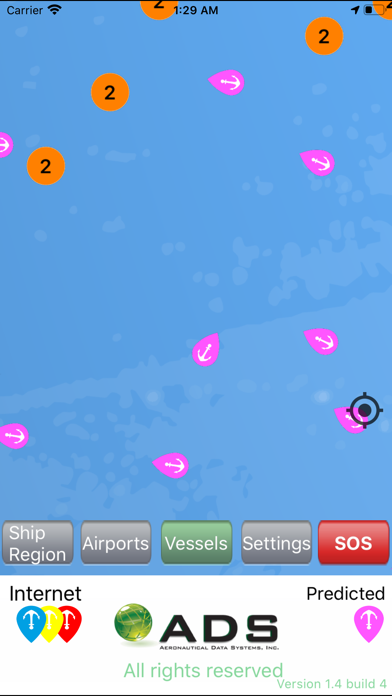


ErgoBlue app for iPhone and iPad
Subscriptions available.
ErgoBlue Monthly Subscription $87.99
ErgoBlue Weekly Subscription $49.99
ErgoBlue Yearly Subscription $999.99
1. Is an iPad app for aviators that displays AIS (Ship position) data world wide.
2. Will transmit to all ships in range a continuous computer generated voice distress message that updates critical flight information every 3 minutes
3. Activates an alarm on the bridge of all deep water vessels, and sends a distress text data message to all ships within VHF range using DSC. Range is proportional to altitude. (This data function is pending FCC approval).
4. Reduces pilot task saturation during a water landing
5. Reduces time of rescue
6. Increases pilot situational awareness
7. Expands ditching procedures to include ditching at night, in low visibility or low ceiling conditions
8. Allows aircraft automation to fly an instrument approach to a ditching if aircraft is so equipped.
9. If aircraft has weather radar will provide a method for ship location confirmation in real time.
If youre a pilot, you know the importance of having the best app for flight planning especially over water where if some goes wrong you will have the safest course of help at your fingertips.
Its an emergency flight landing app that will provide the most accurate data set to manage a water landing—and it is the only aviation GPS app for iPad/iPhone on the market that delivers this type of planning/data service. ErgoBlue is one of the best pilot apps for iphone/iPads that pinpoints the exact location of aircrafts relative to airports and ships to provide pilots with a quick visual guide for emergency landings. If you have to make an emergency landing, you can use ErgoBlue to get to the nearest airport or ship.
In addition to its automatic distress signal, the app can transmit a continuous mayday call (voice and data) over the maritime distress frequency, Channel 16, which provides ships within the VHF range with continuously-updated aircraft information. The ErgoBlue app increases a pilots situational awareness while simultaneously reducing pilot task saturation during high workload, high stress emergency situations. ErgoBlue is the best iPad flight apps options for emergency landings by providing an immediate picture of whats nearby.
In addition to its emergency services, pilots also use ErgoBlue for flight planning purposes. While some airlines require flight plans for all flights, many do not need them unless youre flying internationally or over certain areas. With ErgoBlue, best app for pilots, they can see where theyre going before take-off to know what kind of fuel tank capacity theyll need based on how high they need to fly to reach their destination safely.
The airplane landing app allows users to enter information about their flight plans. In addition, it will provide them with accurate maps showing where they are relative to airports nearby and other potential landing sites if necessary. It also has a built-in GPS capability to track each users location throughout flights to know exactly where they are when emergencies arise.
With ErgoBlue, you can plan your flight path and get information about airports, runways, and develop emergency contingency plans before leaving the ground. This is one of the best ipad apps for aviation because it has a simple interface that makes it easy for pilots to use in any situation and is the only iPad/iPhone app that provides real time geo-spatial ship position in the world today.
Ergo Blue should be a part of any overwater flight since it plans for the worst case scenario and complies with SMS protocols.
Terms of Service / Privacy Policy
https://adsopp.com/eops/terms
Disclaimer:
Continued use of GPS running in the background can dramatically decrease battery life.